WELCOME TO MY BLOG

I hope you enjoy reading it. I will try to put entries in weekly. I look forward to getting some comments. PS. DON'T FORGET THAT YOU CAN ENLARGE MOST OF THE PHOTOS FOR BETTER VIEWING BY CLICKING ON THEM.

Travel Plans: FEB 4: Dep. Brisbane 12.10 pm. FEB 4: Los Angeles 7.00 am. FEB 5: Los Angeles - Albuquerque. FEB 5 - MAY 15 : Sangre de Cristo. MAY 15: Chicago to London. MAY 16: London. MAY 21-15: Lourdes. MAY 25-28: London, MAY 28:Via Paris to Issoudun. JUNE 2:Paris. JUNE 5:Paris via London to Rome. JUNE 12:Dep. Rome. JUNE 13:Hong Kong 6.45 am. - 11.15 pm. JUNE 14:Brisbane 9.40 am.

Sunday, April 29, 2007

Pecos, Walk Up the Green Trail, Jemez Mountains

A. PECOS Dear All,
I promised I would publish a little about a very interesting trip we had to Pecos in the week after Easter. It is a national monument some way outside Santa Fe, on the north side. The history of the site goes back 12,000 years, and includes "the ancient pueblo of Pecos, two Spanish colonial churches, Santa Fe trail sties, the 20th-century ranch history of the Forked lightining Ranch and the site of the Civil War Battle of Glorieta Pass."

A Spanish visitor's log from about the 15th Century described the “nearly 500 warriors” of the fortress-like pueblo at Pecos National Historical Park as “feared throughout the land.” Called Cicuye by the Spanish, the red stone community peaked in the mid-15th century as the Southwest’s preeminent pueblo trading center. About 2,000 people occupied an apartment-like complex of some 1,000 rooms reaching five stories.

Disease and hostile tribes reduced its population to 17 in 1838, when the survivors emigrated to join the Jemez Pueblo.

The land for the National Park Site we visited, where the ruins of the Pueblo and the Spanish Church can be seen, was donated by the film star, Greer Garson, and her husband who lived on a ranch we passed as we drove along the road to the site. Greer and her hubbie appear to have been very involved
and there are photos of the couple (can't remember the surname, but it started with 's' - very helpful!) in the museum which is next to the shop and theatrette where we saw an excellent film before touring the ruins.

It is obvious that the site had great advantages for settlement with the fertile valley of the Rio Grande just below it, and this may be why so many people were able to live there. The walls had no external windows, so it is obvious defence was very important, with other tribes likely to attack in the constant wars that erupted between rival groups. Not much has changed, has it?

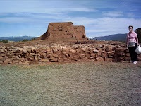
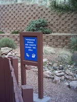
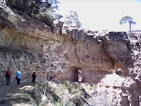
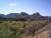
1. Looking over the Rio Grande valley from the Pecos Pueblo site2. Myself standing in front of some of the ruins with the Spanish-built church in the background3. The remains of walls of roomsThere was a period of Spanish rule at Pecos from about 15th century, then the tribes rose against their new rulers in a bloody restoration of their former life-style. A year or so later, the Spanish (with their Catholic religion - the main motive for much that went on) returned and were welcomed back, but there were various ups and downs. During the American Confederate-Union conflict, a famous battle was fought at Glorietta Pass nearby. I'll just show a couple more photos. The Pecos people had a remarkable social, economic and religious life before the Spaniards. Below, you will see a plaque about the ruins of the Church 
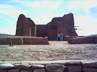
(hopefully you can read it if it enlarges), then there is a photo of the ruins as we saw them, from the same angle. Then, on th right you will see Anne entereing a 'Kiva'. These were sacred rooms accessible only by ladder, circular in shape.

B. UP THE GREEN TRAIL
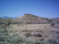
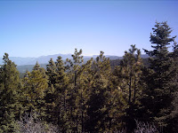
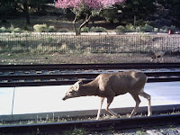
Last Thursday, I went up a trail I had never been on. I did not go its full length - that awaits my further exploration - but it was very nice and I really liked it. A fair length of what I walked followed a stream coming from the melting snow of the Mountains behind. The trees were mostly Ponderosa Pine - one of the best wood trees in the State, and perhaps America. There were also Pinyon and a few other species plus grass! I actually saw a couple of Donkey Deer quite close (about 20 feet away) after lunch, when I was quiet. They didn't see me for a small while, but when they did they did their characteristic vertical bounces on their legs to get off to a very swift start. I took a photo, but you will find the one little deer, mid-picture, hader to spot than the squirrel at the Grand Canyon. Here are a couple of nice views along the Green Trail. The third one (on the right) has a deer in it. Good luck! It is in the middle of those ponderosa pines on the right side and, even if you enlarge the picture, you will be lucky to see it!
C. JEMEZ SPRINGS SURPRISE TRIP
This weekend, ten participants are taking part in a Wilderness Weekend. The 25 of us who remained were taken on a Surpise trip on Friday which proved to be in the same area. In fact, on the way home, we stopped by the group as they did their first repelling (abseiling) down a big cliff beside the road. It was all very organised and safe, but very scary for those who have never done it before. I have no photos of that because my battery ran flat in my camera.
The trip up was interesting. We passed close to (but didn't go into) Los Alamos, where it is said that there are more nuclear weapons stockpiled than in any other part of the globe! We certainly noticed National Chemical Laboratories in several places, but did not go into the town which is thriving because of huge inputs of Federal money for weapons!!!! A hard ask for the locals who value the income - but at what price?
The scenery on the way to the Jemez Mountains was very different and changed often. Here are three samples (some slight blurring close to the road, but not too bad taken from a moving vehicle)
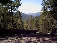
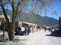
Within the mountains we stopped first to view a Caldera from 10,000 years ago - which presented as a vast, high alpine plain (explanatory photo only). We also pulled in at a lookout to look at marvellous views (2nd photo)We pulled up next at where some hot springs emerge at the roadside, and climbed a rock over the river. You can see yours truly posing on the rock! After than, we went to 'Battleship Rock' picnic area for lunch.
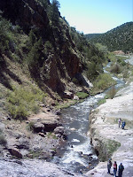
It was a beautiful lunch spot, and not too busy, being Friday. A Youth Camp was next door, but we didn't see anybody. There were good parking and toilet and picnic table facilities. This was right on the stream and we walked up behind the rock and there was a beautiful waterfall. I'll show you 1. a photo of Battleship Rock. The angle doesn't show the battleship shape - that would have to be from side-one, but you can see how impressive it was; then 2.there is a picture taken a bit away from the picnic area, from another rocky outcrop (much, much smaller than battleship rock) beside the road, looking down on the beautiful, snow-fed stream in the area. Some of our group are milling around. then, 3.you'll see a picture of myself at the waterfall - a bit out-of-focus, but you'll recognise me;
Well, that is surely enough for this week. Life gets busier and busier. The farewell gatherings have already started and our Prayer Group is going out next Saturday evening. Then on Sunday 6th we give a 'Thank you' dinner for all the Staff. We have only one lecture series to go, and one excursion to go. All too soon, I'll be winging my way to London via Chicago. Ah well, that is why I came - can't stay here forever.
God bless! Rita

Monday, April 23, 2007

Spring and Taos

Dear All,
Little bits of trivia first: the Humming Birds have arrived and are feeding in the courtyard at the honey-water bottles. I managed to get a few photographs - even 1. one showing a bird in flight, 2. another one settling on the rail as it finishes hovering with its wings moving at 40 times per second, and 3. one looking up after having dipped into the honey hole at the base of the bottle. It would be about 6 cm long at the most.
The arrival of the humming birds coincides with the flowering of cactii, especially the cholla which you saw in a previous blog. The cholla are branched and have tight yellow flowers at the end of each stalk. The humming birds hover to feed from them. The cactus prickles are quite savage, I have discovered - they go right into your skin about a millimetre or two immediately upon contact, and there they stay until you pull the needle-like point out. I did not take long to learn to give cholla (and other cactus) a wide berth!
The picture on the right shows a little 'pin-cushion' (my name) cactus in flower. These are all over the hills out here at present, flowering profusely. Quite delightful! I took this photo when I climbed 'The Needles' on my last desert day. Obo came with me and I took a picture of him (on left) admiring the scenery during our descent. I did not 'invite' him, but as I walked out the front door, pack on back, he jumped up and joined me. As we climbed the needles he started to walk more slowly, making sure he was in the shade of bushes and lying down, panting, whenever he had a chance. So I tried out a snack on him - banana! He ate it! I shared one actually - a piece for him, a piece for me. Since I had two water bottles, I let him drink out of one; he was a bit wasteful, lapping at the opening, but looked very enthusiastic and grateful. Later - much later, after we descended to running water, he had half of my sandwich - vegemite, peanut-butter & celery - gobble, gobble! Then I ate my apple and tried a piece on him - crunch, crunch! Another piece went the same way, and then I gave him the core at the finish. Crunch, crunch - all gone! What a dog! He also took raisins with enthusiasm, although I rationed them carefully.
TAOS
Last Friday (19th) we set out at 8.30 am for Taos - nearly two hours away for our convoy of 4 vehicles containing about 40 people. It is quite a good sized town - nearly as big as Santa Fe - and one of the main focii of our visit was the Taos Pueblo. We took the High Road in, renowned for its beautiful scenery across fir tree forests to snow capped peaks of the Sangre de Cristo Mountains in the distance, and we stopped for a photo opportunity. Then on to dear old MacDonald's for a 20 minute refreshment stop (no photo!). We had to be at the Pueblo by 11 am for a one hour visit. To quote from the website (www.taospueblo.com) "Taos Pueblo is the only living Native American community designated both a World Heritage Site by UNESCO and a National Historic Landmark. The multi-storied adobe buildings have been continuously inhabited for over 1000 years." So here are a couple of photos to give you the idea:
1. View from High Road to Taos 2. Street in the Pueblo 3. Buildings in the Pueblo
Some of our group joined a tour led by 'Sunflower' (or was it 'Snowflake'). She told them that the Pueblo has no electricity or running water and is those in it live at a very simple level. Wood in Kiva fire-places are used for heating. Visitors are welcome during work hours, but not allowed into private areas. Those born into the Pueblo belong there and have matrilinear inheritance rights to the buildings. They retain those rights if they choose to live outside the Pueblo. If they marry an Indian of another group, they retain the rights. If they marry a non-Indian they lose them. They are not required to live there and only about 20 people do live the traditional life there. They have their own law and do not pay US Government taxes, hence things we purchase could be cheaper there! They have their own Church and grave-yard and practise both Catholicism and traditonal Indian Religion. They sell crafts to tourists and pueblo breads etc. Here are a few photos you might find of interest:

1. St Geronimo (Jerome) Church 2. A Craft stall at entrance 3. View over fence into Cemetery
I bought a few little things there and it was very interesting meeting some of the people who make much of what they sell. Here are a couple:
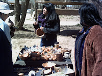
1. 'Divine Harmony - 2 yrs 6 mths beside her grandfather doing craft. She has an 'abstract' painting, framed, on the wall!
2. This stream provides water from melting snow. The young guide, 'Sunflower' is just crossing it.
3. This man was proud to stand beside his Kiva fireplace for a photo. He had his son's school certificates proudly hung on the wall above where he sat.
After our one hour visit, we went down to the Taos square to look around and eat some lunch. It was not very busy but it was hard to find a place to buy something simple like a sandwich and coffee. Some brought their lunch (the wise ones!) and the rest of us fossicked. I settled from two cereal bars I was given plus an apple I brought and some water. I also bought a T-shirt.
1. A notice about the Plaza
2. These park seats are apparently common in New Mexico; they show the four seasons. There are variations on different seats.
3. Hopefully this map of the Taos district will enlarge if you click on it.
Our next visit was to a bridge over a gorge on the Rio Grande river a few miles outside the town. This was really quite interesting as the gorge, though not quite on Grand Canyon scale, was very impressive. There were also excellent views of the Sangre de Cristo peaks from this location. We drove across the bridge, were dropped off, then walked back to where the vehicles had returned to park. Some with vertigo tendencies did not leave the vehicles!
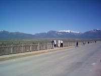
1. Looking east from the bridge
2. Group crossing the bridge - lovely mountains behind.
3. Myself on the bridge.
No day out would be complete without doing some Church visiting! We parked in the grounds of Our Lady of Guadalupe Church in Taos itself, and had a chance to look inside. There is no doubt about the importance of the Our Lady of Guadalupe story in the Church. There are murals, statues and a special shrine all showing various representations of Juan Diego talking to Our Lady or opening up the cloak in which he put the roses and finding the picture of Our Lady of Guadalupe imprinted upon it. I'll show you a selection:
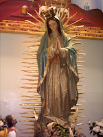
Finally, before heading for home, we called in at a very very old church - San Francisco (St Francis) also in Taos. It wasn't open since we were late (after 4 pm) but the lady who had been there all day showing visitors around, came back specially and opened it for us. No photos are allowed inside the Church, so any taken are outside.


1. San Francisco de Asis Church 2. A Gravestone in the courtyard 3. Tulips in flower (back in the Plaza!)
It has been very enriching during the Sabbatical Course here at Sangre to visit places of great significance. You have yet to see a blog on Pecos - which was a wonderful morning out! To quote from a website about it: "Pecos preserves 12,000 years of history including the ancient pueblo of Pecos, Colonial Missions, Santa Fe Trail sites, 20th century ranch history of Forked Lightning Ranch, and the site of the Civil War Battle of Glorieta Pass."
Time is running out here, so I hope I will get time to put some of this on a blog. In the meantime, don't get 'indigestion' ploughing through it all, and I hope the photos do enlarge - at least the left and right ones! Bye for this week. Rita

Tuesday, April 17, 2007

The Big Excursion - Grand Canyon etc.

Well, at last I've seen it with my own eyes! The Grand Canyon. Awesome! I took so many photos that you will see only the best few, carefully selected. Of course we had to drive there and away again, so took time to visit a couple of other places, the first being the Painted Desert which includes the Petrified Forest. On the way back we went to Sedona, famous for the huge Red Rock mountains which surround it.
THE TRIP
1) Snowy view early on the way 2) Group near Border 3) Danger Sign!
When we left, at 5.30 am on Friday morning, the weather was not good. Near Albuquerque, there had been, and was still, snow. We rejoiced then when we reached the border of New Mexico and Arizona, taking time to pose and inspect the possible dangers of the neighbouring State! The Highway across this part of the world was very busy with many many large rigs tearing across. I think they may be bigger than Australian semis. The highway is two lanes each way, with a divided section which varies in width. The surface is generally good. On either side the countryside rolls away into the distance and, as we got further and further into Arizona it became drier and the trees fewer, until we arrived at Flagstaff which is a much more mountainous area with forest of firs.
THE PAINTED DESERT
After many hours we were able to turn off and visit the Painted Desert
You can see a couple of views above, and also a picture of one of our members braced against the freezing wind which shortened all our lookout visits considerably! Then we moved into the Petrified Forest areas. If you imagine the trees are standing in forest formation, forget it! The huge red cedars were carried to this place by water and buried in silt etc many aeons ago. As a result the wood turned to rocks of amazing colours. Below you will see a fallen, shattered log, and then two cross-sections of logs showing a colour of major colour varieties. There were many variations in the colours. Apparently the 'forest' was plundered for many years by settlers and large parts removed when the train line passed by and a means of easy transport became available. Eventually it was made a national treasure with penalties for removing pieces. Only 10% of the Petrified Forest lies within protected land so there is plenty for the plunderers outside that, but still, every month, the National Treasure loses a ton! A shame.
THE PETRIFIED FOREST
1) A shattered Red Cedar Petrified Log; 2) Cross-section showing beautiful deposits in logs; 3) Another Cross-section showing different deposits
We drove past Flagstaff to Williams, a bit further across Arizona , and checked into our Motel for the evening. The rooms were shared, but I was fortunate enough to have a Queen bed to myself! There were three women in my room and everything worked - shower, hot water, coffee maker, room heater - not like next door where four women froze the first night and on the second dressed in every item of clothing they could find to survive the night! [They succeeded].
THE GRAND CANYON
On Saturday, we headed off (not too early - 8.30 am) to the Grand Canyon. We were rather excited. It was about an hour's drive. through beautiful forests with signs occasionally warning of possible deer romping around. First port of call was the Nationatl Geographic Information Centre where you can buy a Pass ($25 per vehicle - we squashed into 2 rather than 3!) and book into the Imax Theatre experience or onto a Helicopter. I took neither because I wanted to experience the Grand Canyon directly. As a result, when some of us were dropped at the Canyon, I had time to go about 2 miles down Bright Angel Trail as well as several miles along Rim Trail. At the end of the day my feet were dragging, but it was all worth it.
The three photos above show 1: My first view of the Canyon; 2: An 'archway early on the way down the Bright Angel Trail; and 3) a bend on this Trail - you can see the buried logs which make steps. You may not be able to see all the Mule droppings which could not be totally avoided and which added their own 'aroma' to the walk!
In the photos below, the first shows a view looking back down the slope where the Bright Angel trail goes, and I think I went to about the upper trail line you can see on this particular view. You can see the trail going on well below this. Then if you look at the next photo , you will see where the trail crosses a much plateau further down before descending out of sight to the Colorado River at the bottom. You won't be able to see a couple of buildings on this plateau unless the picture enlarges (the middle ones don't seem to!) but they were there- no doubt Ranger's buildings. People go down the trail to the bottom of the Canyon and up the other side to the North Rim. There were some very enthusiastic (and fit-looking) individuals charging up and down when I was there. I did not see the mules in action but a couple of the others did and they said the passengers looked very weary after about 9 hours in the saddle - leaning backwards on the way down and reverse on the way up! Not for the faint-hearted, but it would save one's leg muscles.
The third picture could be called "spot the squirrel"! Look on a rock on the lower left of the picture. These little creatures squirmed in and around various bushes, darting from one place to the next with not much fear of the passing traffic. See how this one actually stopped and looked at me!
1) Bright Angel Trail slope 2) Bright Angel Trail far below 3) Squirrel
And now, I can't resist publishing three more views of the Canyon out of my extensive repertoire! You can see great variations in colour & formation.
We left the Canyon late and had a meal on the way back, getting to Williams about 9.30 pm.
SEDONA
The next morning we headed for home via Sedona. Sedona is south of Flagstaff and is a very picturesque place which has high visitor number. You will see why if you look at the pictures below. The town itself is surrounded by wonderful mountains and the drive in was lovely as we wound along valleys with dwellings, settlements and wilderness camping areas, all with vegetation greening for spring and a rocky stream in the centre. (The weather, by the way, fined up on Saturday and was still sunny on Sunday).
The first picture above shows the eastern backdrop to the town; the second is towards the north east over a greening valley; the third shows a magnificent sclupture (there were plenty) in a town geared to tourism with a large variety of shops offering suitable wares, food etc.
Below you can see that 1. they cater to tourists with a free bus (of course Grand Canyon has three buses which go up and down three sections of the Rim all day - I caught one back to the area I came from when my camera battery expired and my feet nearly died at about 4 pm on the Saturday!)
The second picture was taken not far from the horse sculpture above and shows a quaint little sculpture just around a corner near an eating place. The third picture shown a fantastic red rock formation (one of many) beside the road south of Sedona which we took to rejoin the highway and return to Flagstaff, from whence we headed for home, tired but weary as all good stories say.
MISCELLANEOUS!
When we were at the Canyon, in the late afternoon, four resident deer emerged to feed. We took many pictures because we could get fairly close, although they were 'tichy', so I will show you a sequence which gives you some idea.
1. You see three of the four deer. 2. This deer tries to move away for more peace 3. He hears a crying child in the distance and stops with great concern, standing like this for quite a while - Thanks, deer!
Finally, I will finish with my most recent water-colour 'masterpiece' - my best yet. Of course, it was copied from a book, but it looks OK!
I must close. I knew this would be a long blog! I've tried to make the setting-out 'user-friendly'. All the best. Rita

About Me

My photo
I am of 'mature age', active, religous and charming of course!